Showing posts with label road trip. Show all posts

Monday, March 12, 2012

Scottsdale 2012, part 6

After leaving Scottsdale, we headed into the Tonto National Forest up to Payson, saying farewell to the saguaros.


This one was amazing. Just look at all the arms.

Payson has lots of historical buildings.

 This beautiful little house, on a hill above the lake, was once Zane Grey's house, now a museum.

Every year the Hashknife pony express still rides through Payson from Holbrook to Scottsdale.

 Along the highway after Payson, there was a turnoff for the Natural Bridge. We decided to go see it. The road was a 15% grade, downhill all the way. By the time I arrived at the bottom, I could smell my brakes. Then, they stopped working altogether. Scary! Fortunately, we were at the bottom and I was able to pull right into the parking lot. I was really worried but decided that with some time to cool them off, everything would be okay. I went into the gift shop and then hiked down to the bottom of the lower parking lot. I snapped this photo while my mom waited in the car.

 The road was curvy and woodsy much of the way.

In Pine, I took this photograph of this old barn and then I saw the people sitting out front and the cars parked in back. Good grief, do they still use it?

Just across the street was this lovely little house that I'd be happy to live in.

This was a country store, still open for business.

Check out this 'out of place' totem. Cool, huh?

We saw a sign for the oldest log school house and decided to go see it.


 They only open it up for special tours but I was able to look inside.

There was still plenty of snow in the high country.

We passed by an area of the forest that had burned some years ago.

 The road seemed to go on and on for miles.

Finally, we made it to the town of Williams

and then on to the red rocks of eastern Arizona - western New Mexico.

This next area was at a rest stop. Beautiful area, isn't it?


I love the sky patterns in this photo even though they are hard to see.
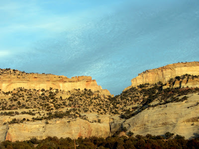
Finally, we made it home, an end to a wonderful mini trip, hard to believe it was only three days.

Friday, December 10, 2010

So Send me a letter, Day 2, part 2

The roadways are really neat nowadays with all the artwork along the sides, aren't they?
After leaving Las Cruces, on our way to Tucson, we decided to visit some ghost towns. Just past Lordsburg is a ghost town called Shakespeare. Click on link for information about the town. We took the low road to get to it.
There are tours through the ghost town every other weekend, However, not on the weekend we were there so, unfortunately, all I could do was look over the fence and point my camera. 
 I'm imagining there's someone behind those curtains.


It must be pretty neat to visit when they have the town populated with reenactors. But for us, it was just a quick side trip and a peek into history. So, we turned the car around and went back the way we came until we joined up with the highway and again headed west. Destination- Tucson.

However, there was another ghost town, Steins, New Mexico, right along the way. Click on link for more information about the ghost town. Also, did you notice how the mountain range is getting closer?
We pulled off to take a look.
There was a man burning weeds but the area was fenced in and closed off. Drat! So, we did the next best thing- a drive-by photo shoot.
 

Can you think of a better way to use an old windmill wheel?

Steins Post office was established in 1888 and discontinued in 1944. Steins was first named Doubtful Canyon due to the constant threat of Indians. One Captain Stein was killed here resulting in the naming of Steins Pass. A few years later, gold and other minerals were discovered here and the town was born as Doubtful Canyon. In 1902 there were 35 registered voters, but many more residents. The current site of Steins is actually a few miles east of the original Doubtful Canyon. Steins survival through the 1940's is due to the fact that Steins was also a rail station on the Southern Pacific. Today, Steins can be seen just off Interstate 10 in Southwestern New Mexico. (from the website)

In our travel guide we read that there were several train robberies in this area in the 1800's. They used to hold up the train just as it would come out of Doubtful Canyon. In the short time we were there, several trains went past. It felt a little like we were experiencing the past.


We stopped at an old trading post (souvenir shop) along the way. Isn't it neat the way they used the Indian's headdress to sell the lollipops?
 
 I don't usually make a habit of cozying up to strangers but I couldn't resist the photo op.
Several times along this stretch of highway we would come across a cluster of four warning signs. There would be this one, then one about do not stop on roadway, another one that I can't remember, maybe high winds may exist, and then one that I wanted to photograph but never did get, warning of ZERO VISIBILITY POSSIBLE. Wow, can you imagine- ZERO visibility??
 We finally entered Arizona and came to this sign.

Bowie, Arizona!
Did we stop there?
What do you think?

To be continued...


So Send me a letter -song: Tumble and Twirl, artist: David Bowie, album: Tonight

Wednesday, December 8, 2010

So Send me a letter, Day 2

In the morning, we drove to La Posta de La Mesilla, again looking for a letter box, in old town Las Cruces (the crosses). Here is the old mission church in the old town square.


I found this gravestone to be very moving and sad. 

I walked around the square and came across La Posta. However, because it was so early in the morning,  it was closed, so alas, no letterbox, because the clues said it was inside the doorway in a planter. The restaurant is still open for business daily.


This sign was in the middle of the square. I was surprised to learn that the Butterfield Overland Trail was even before the Pony Express.

This was an interesting sign and building on the square.

Here's the building the sign referred to. Neat doors, huh?

This was another historical building.

Here's a closeup of the sign.


Isn't this a pretty store front?

We decided to go explore some of the side roads near the square. After driving a few miles, we ended up in the heart of the agricultural area.

There was cotton growing in the fields along the way. Does anyone understand this sign? Does it have to do with the cotton fields?  

Between the pecan and pistachio orchards and the cotton fields, I think the land owners have done rather well for themselves. Just look at the size of this house!

Notice the hot air balloon in the sky?

Here are more photos of the Organ Mountains.

We drove over to the Rio Grande river. It wasn't so grand though.


In closing, here is a real ship of the desert, right?

much more to come...

So send me a letter - song: Tumble and Twirl, artist: David Bowie, album: Tonight