
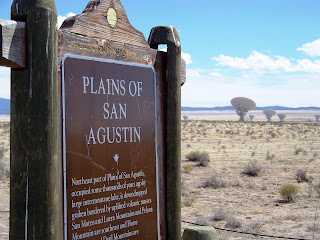
 The Very Large Array, one of the world's premier astronomical radio observatories, consists of 27 radio antennas in a Y-shaped configuration on the Plains of San Agustin fifty miles west of Socorro, New Mexico. Each antenna is 25 meters (82 feet) in diameter. The data from the antennas is combined electronically to give the resolution of an antenna 36km (22 miles) across, with the sensitivity of a dish 130 meters (422 feet) in diameter. For more information, see overview of the VLA. The array is currently in the B configuration.
  Here's Lisa and I standing near one that was being worked on in a hangar. I wonder what they need to do to fix them?
 An interesting fact about Pronghorn Antelope is that both males and females have horns. Also they do not lose their horns and they are not antlers.


 I'm not sure what happened with the lighting in this picture but doesn't it look kind of "alien abduction" or something?
  Here's Lisa's Bionic leg.
 Thirty-six miles west of Magdalena, at the western edge of the San Agustin Plains, the Datil Mountains rise and pinon and juniper trees emerge from the bush and grass. At the intersection of U.S. 60 and S.R. 12 at an elevation of 7500 feet sits the town of Datil.
To the Spanish settlers the seedpods of the prevelant yucca resembled dates, and "datil" is the Spanish word for date. Levi and Fred Baldwin established the first Datil store and post office in 1884 to serve the cattle ranching families.


Originally called Norman's Place, Pie Town is located 22 miles west of Datil on the Continental Divide. The altitudes of 7,900 feet has proven healthy for the town's 55 inhabitants.
Pie Town earned its name in the 1920s when Clyde Norman, owner of the town's gas station and cafe, began selling pies to automobile travelers on U.S. 60. In 1934 the area around Pie Town was opened up to homesteaders. Using dry land farming, the homesteaders grew pinto beans until 1956 when the lack of snow and rain made this unprofitable. more info here


 Twenty-one miles further west on U.S. 60 at the lower altitude of 6970 feet lies Quemado, named for the Spanish word for "burned." When Jose Antonio Padilla settled by a creek east of the present town in 1880, he found that the surounding brush had been burned by the Indians, so he named it Rito Quemado.
 With three cafes, three motels, two garages, general and hardware stores and the only high school in the northern part of the county, Quemado is a service center for the surrounding ranching community and the 250 inhabitants of the town. The cut stone small Catholic Church at the east end of town with its tiny graveyard is well worth a photograph, as is the tree made of deer antlers.
We didn't see the deer antler tree but we did admire the church. The school was really nice too.
We turned into this little canyon area for a pit stop. In the middle of the hill above the bathrooms was a tiny little sign. (click on photo for zoom and look closely) Further investigation revealed that it was a "no camping" sign. Would anyone really want to camp up there?


A short walk up a footpath gave me some spectacular views.

Then it was back on the road again for the long way home. 
To be continued...
Ghost town approach, part II
5 comments:
Very Very cool! So that's what the Morley monument was all about!
You are so good at digging up info and facts about places and stuff, girlfriend! :)
And...bionic leg. You're funny. LOL!
~Lisa
I love exploring old towns like this! Thanks for taking me along. And that cow was funny!
Thanks again for the memories, we know these areas, too. I'm assuming you went from Quemado up to Highway 40 (old Highway 66) near Grants before you headed back. :) I'm checking back to see! I also linked to your Magdalena post and this one.
Thank you so much.
Great pictures, Val. Pie Town is also the home to a great operation that makes some very tasty goat cheese.
Dan
I really need to visit these places. You two (Lisa) sure make touring the state look like a whole lot of fun.
Post a Comment