
 Just to the right I can see South Mountain.
  This is what I see when I look out my bedroom window to the west. I love my little stone wall!
 While I was looking outside, I saw these birds on the top of a telephone pole. Does anyone know what they are?
 This is looking to the west from my kitchen window. My barn is at the far right. This photo was taken just a few days ago. Almost all of the snow is gone now.
Because of the snow, Gunnar and Daisy had to stay inside. I took the opportunity to get some pictures of Daisy. 

Terra was showing exceptional attitude.


 Not to be left out, here's Gunnar.
And, of course, here's Buddha. He is giving High 5's. You can see how hairy his toes are in the last photo. He spreads his claws like a cat.


Here I stand, foot in hand - All the Madmen, artist: David Bowie, album: The Man Who Sold the World


 Who says New Mexico doesn't have tall trees? These were huge!
 There was a even natural arch called Ventana Arch.
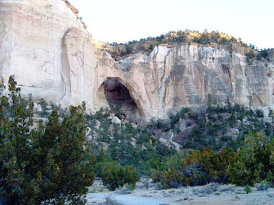

 Can you see the face pointing to the right? I think it looks oriental or Hindu, maybe a fertility goddess?
 Isn't this pretty? It's like an island in the sunset.
 On the way home we stopped for gas. They had a couple of huge pieces of petrified wood. I guess the green must be lichens growing, or the lighting.

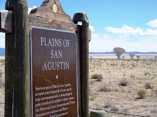
 The Very Large Array, one of the world's premier astronomical radio observatories, consists of 27 radio antennas in a Y-shaped configuration on the Plains of San Agustin fifty miles west of Socorro, New Mexico. Each antenna is 25 meters (82 feet) in diameter. The data from the antennas is combined electronically to give the resolution of an antenna 36km (22 miles) across, with the sensitivity of a dish 130 meters (422 feet) in diameter. For more information, see
  Here's Lisa and I standing near one that was being worked on in a hangar. I wonder what they need to do to fix them?
 An interesting fact about


 I'm not sure what happened with the lighting in this picture but doesn't it look kind of "alien abduction" or something?
  Here's Lisa's Bionic leg.
 Thirty-six miles west of Magdalena, at the western edge of the San Agustin Plains, the Datil Mountains rise and pinon and juniper trees emerge from the bush and grass. At the intersection of U.S. 60 and S.R. 12 at an elevation of 7500 feet sits the town of Datil.


 Twenty-one miles further west on U.S. 60 at the lower altitude of 6970 feet lies Quemado, named for the Spanish word for "burned." When Jose Antonio Padilla settled by a creek east of the present town in 1880, he found that the surounding brush had been burned by the Indians, so he named it Rito Quemado.


